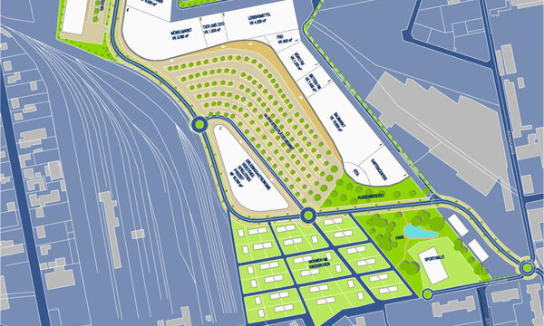
Arena Transportation and Parking Mannheim-Bösfeld
Mannheim, 2001
Urban and transportation planning study on the development of a synergistic convention area and sport park
Use
Mobility
Timeframe
2001
Client
City of Mannheim

entrance and exit schematic
In 2001, the City of Mannheim officially announced its intention to develop a "Mannheim Sports and Exhibition Park" in the area known as Bösfeld. The first step entailed building an arena across from the existing exhibition site. The area is located in the eastern part of the city with a direct connection to freeway A 656 and highway B38a, that is, in the middle of an efficient yet heavily used transportation network. Transportation planners from AS+P were needed to accompany the planning process by studying the possibilities for adding parking and contributing an expert opinion regarding the surrounding transportation network. Some essential aspects of the study were the determination of the necessary number of parking spots and a concept for internal and external traffic connections as well as parking. Strengthening the public transportation network by building a new subway station as well as extending the trolley line was also considered. A fundamental part of the development plan process for the arena was obtaining the expert opinion of the transportation planners. After investigating traffic generation, mode allocation, mode preference, and route preference, the performance capability of the routes and intersections was tested and evaluated. Of particular importance was the analysis of traffic and parking load while events occur simultaneously at the arena and exhibition hall.

Mannheim-Neckerau connection point

Mannheim-Neckerau connection point